


Drawings for "Journey on the Amur" - Richard Karlovich Maak, 1859
Album of drawings depicting the Amur River at the time of Russian annexation

Preliminary note: For Gmail readers, this essay might be clipped due to size limitations. To read the entire essay simply click on “View entire message” at the bottom of the email, thanks.

Introduction
Below are the illustrations for Richard Karlovich Maak’s travelogue “Journey on the Amur, completed on the orders of the Siberian Department of the Russian Geographic Society in 1855” from 1859.
Richard Maak was a Baltic German from modern day Estonia, which then was a part of the Russian Empire. Born in 1825, he became a botanist and geographer after graduating from the University of Saint Petersburg and later wrote several travelogues and studies about the Amur and Ussuri River regions, which today are known collectively as the Russian Far East. Upon graduating in 1852 he decided to travel to Siberia to study it’s natural environment. He entered into the service of the Main Directorate of Eastern Siberia and joined the Siberian department of the Russian Geographic Society (RGO).
His first expedition in 1853 was to Yakutia, a region north of Lake Baikal, where he studied the area around the Vilyuy River, a tributary of the Lena. The expedition was sponsored by the RGO, in addition to support from local merchants and Nikolai Muravyov-Amursky, the Governor-Governor Eastern Siberia. Shortly upon returning to Irkutsk in spring 1854, Maak set back out, this time to to the Amur River. Along with collecting samples of flora and fauna, Maak also made several topographical maps, discovered deposits of brown coal, salt and rare minerals, and gathered ethnographic information on the region’s natives.
His account of his trip, “Travel on the Amur” was published in 1859 thanks to the patronage of a wealthy Siberian merchant Stepan Soloveyov, who paid for the printing of the book. For the expedition, Maak was rewarded the Cavalier of the Order of Vladimir 4th degree and a pension of 300 rubles a year. In 1859 he set back out explore the Ussuri River, a tributary of the Amur. This expedition was sponsored entirely by private donations, with one anonymous person giving 3000 rubles.
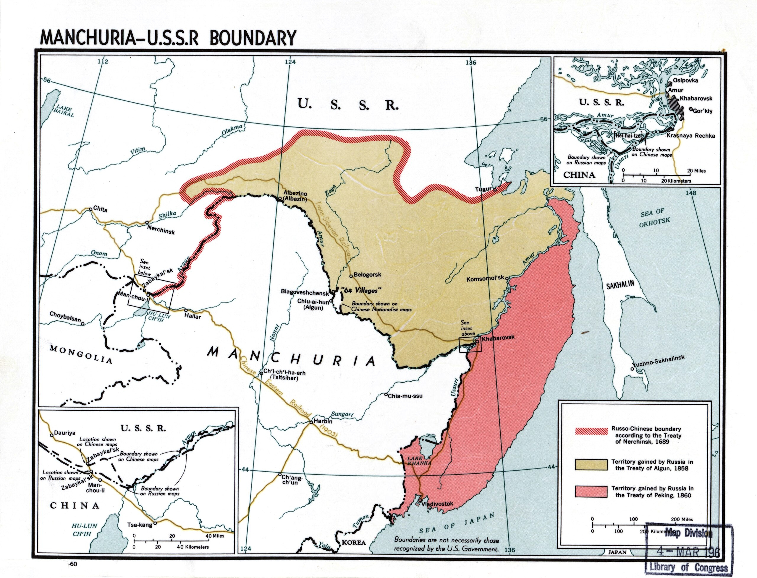
At the time of Maak’s expedition, the basin of the Amur River was still a part of China’s Qing Dynasty. Following a short border conflict in the later 17th century between the Tsardom of Muscovy and the Qing Dynasty which culminated with Russia’s defeat at the Siege of Albazin in 1686, the Russo-Chinese frontier was set at the Stanovoy Range, approximately 350 kilometers north of the Amur River.


Russia’s frontier with China in Siberia remain fixed for the next 160 years, until Russian ambitions towards the Amur River were revived following its defeat in the Crimean War. Reeling from this defeat, Russia sought to restore its lost prestige and saw annexation of the Amur as a means to achieve this. It believed that the Amur would connect Siberia with the Pacific Ocean, opening up Siberia’s continental interior to trade with the wider maritime world. It was also believed that vast, untapped agricultural lands laid along the Amur, which once cultivated, could feed Siberia’s cities and ensure that they would no longer be dependent upon food supplies from European Russia. Russians such Muravyov-Amursky overtly believed the Amur would be Siberia’s Mississippi, and saw it was a necessary piece of territory for Russia’s own “Manifest Destiny” in Asia.
With China simultaneously racked by the Taiping Rebellion along the Yangtze River and threatened by England and France during the Second Opium War, which saw a joint Anglo-French force capture Beijing in 1860, Russia returned its attention to the Amur in the late 1850s. Taking advantage of China’s weakness at the time, Russia forced China to cede the left bank of the Amur in 1858 with the Treat of Aigun. Two years later in exchange for diplomatic and military support, the Qing signed the Treaty of Peking, ceding the right bank of the Ussuri River to Russia, which included the site of modern day Vladivostok. It is worth noting that neither of these territories were particularly important to the Qing Dynasty. Inhabited mostly by Siberian indigenous peoples such as the Goldies, these tribes merely had a tributary relationship with the Qing Empire.
For more on the Russian annexation of its Far Eastern territories, I would highly recommend "Imperial Visions: Nationalist Imagination and Geographical Expansion in the Russian Far East, 1840–1865" by Mark Bassin, and for a
I first posted this drawing album on Twitter/X and I decided to repost it here, for archival purposes. I discovered this album while researching for a previous translation I posted here about the Mariinsky Post on the Amur, which can be found here. An article on Maak and his expeditions published by the Russian Geographic Society can be found here. Lastly, a high quality scan of the album can be accessed here.
The drawings’ titles are placed below the image.
Album of Drawings for "Journey on the Amur"


Covers and Title Pages

View of Shilki at the Mouth of the River Luchuya

View of the Shilka at the River Bondikovo

View of Shilka about 45 verstas above Ust-Strelki

View of the Amur at the Entrance of the Khingan Range

View of the exit from the Khingan Range

Residents of the Mouth of the Sungari

View of the Amur and the Cliffs on the Shore at Derki

View of the Amur near the Village Dyren

Goldies, Travelling with Dogs

Travelling and Hunting Dogs on the Amur

Manguns

Mangun Winter Village

Interior of a Mangun Winter Home

Mangun Tomb

Tomb of a Mangun Shaman

View of the Mariinsky Post

Residents of the Amur


Homes and home items


Clothing and weapons


Fishing tools and boats & patterns

Atlas section

Plan of the Albazin Fortification and the Chinese Camp

Plan for a part of the Town of Aigun

Map of the spread of trees and bushes along the shores of the Amur

Geognostic map of the shores of the Amur


Flora

Title page for “Journey on the Amur” - Nikolai Muravyov-Amursky on the left
End
Interesting history lesson and great pictures! Colin Thurbon has an interesting book on the Amur as well.
Great post!